
Radnorshire
- Eleanor Conlon

- Nov 10, 2025
- 4 min read
Updated: Dec 31, 2025
Where is Radnorshire?

In our episode about the historic Welsh county of Radnorshire, we mentioned lots of interesting places and things, so here are some images and links if you want to find out more!
Battle of Bryn Glas

The Battle of Bryn Glas (also known as the Battle of Pilleth) was a battle between the Welsh and English on 22 June 1402, near the towns of Knighton and Presteigne in Powys, Wales.
It was part of the Glyndŵr rebellion of 1400-1415. It was an important victory for the Welsh under Owain Glyndŵr, as it resulted in the prolongation of the Welsh war of independence and the destabilisation of English politics for several years afterward.
Llandrindod Wells

Llandrindod Wells is a town and community in Powys, Wales. It serves as the seat of Powys County Council, and is therefore the administrative centre of Powys. The town was historically in Radnorshire.
Llandrindod Wells developed as a spa town in the 19th century, with a boom in the late 20th century as a centre of local government. Before the 1860s the site of the town was common land in Llanfihangel Cefnllys parish. Llandrindod Wells is the fifth largest town in Powys. The population as of the 2021 UK census was 5,602, an increase on the previous census
Radnorshire Museum
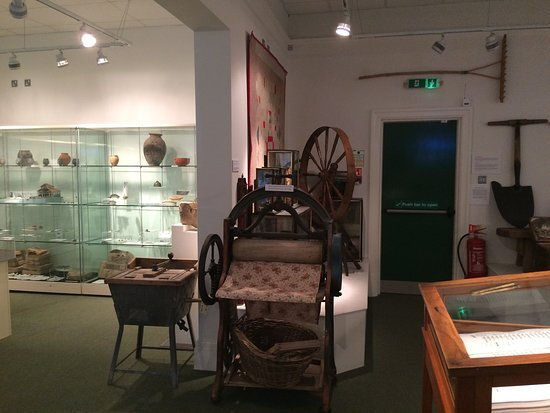
Radnorshire Museum is located in the centre of Llandrindod Wells and holds collections relating to the former county of Radnorshire. The museum is housed in the former Carnegie Public Library.
Its collections include items from pre-historic to medieval periods including the Llandrindod Wells Log Boat and Sheela na Gig, the Castell Collen collection and an outstanding collection of Ordovician specimens from the Builth-Llandrindod Inlier.
Water-Break-Its-Neck Waterfall

Warren Wood is one mile south west of New Radnor in the area known as Radnor Forest which was once a royal hunting ground. It has been popular with tourists for over 200 years because of the waterfall known as Water-Break-its-Neck.
Today the Radnor Forest is a land of hill farming and great moorlands, steep narrow valleys and hills, rising up to the highest point in Radnorshire, Black Mixen at 2150 feet (650 metres). The two other woodlands within the Radnor Forest are Nash Wood and Fishpools.
Cefnllys

Cefnllys is an abandoned ghost village, formerly a medieval castle town and borough, near Llandrindod Wells in Radnorshire (now part of Powys), Wales. The settlement was founded during the 13th century by the Mortimer family in order to strengthen their hold on land in the vicinity of the Cefnllys Castle, with which the town was closely associated.
The town was probably intended to become the primary settlement of the lordship and cantref of Maelienydd, but was unsuccessful and declined during the 14th century as a result of bubonic plague outbreaks, economic isolation and military insecurity. Despite this, Cefnllys retained its borough status until the 19th century.
Cymhir Abbey

The founding of the Abbey of Cwmhir was part of the extraordinary expansion of the Cistercian Order inspired by St Bernard of Clairvaux in the 12th C. It was founded by the Welsh Lords of Maelienydd (Radnorshire) descended from the house of Elystan Glodrydd which ruled the area between the Severn and the Wye – Rhwng Gwye a Hafren.
One of the many mysteries of Abbey Cwmhir is that one of the earliest Cistercian historians, of the 16th C gives two dates for its founding, 1143 & 1176. Both are championed today although most specialists prefer 1176 when the powerful “King” or Rex d’Elfael, Cadwallon ap Madoc was ruler.
Elan Valley Nature Reserve

The 70 square miles of moorland, bog, woodland, river and reservoir are of national importance for their diversity of lower plants (mosses, liverworts and lichens) and the Estate is the most important area for land birds in Wales.
Most of the 180 square kilometres of the Elan Estate is covered by 12 separate Sites of Special Scientific Interest. Within the Estate is the Claerwen National Nature Reserve, 800 hectares of upland plateaux with gently rolling hills covered with acid grassland and in parts, blanket bog on a mantle of peat. Grazing has been reduced on the reserve to protect species like bog mosses, bog rosemary, cotton grasses and heather. This bleak upland provides breeding or feeding ground for scarce birds like the dunlin and golden plover.
Llandrindod Wells Sheela Na Gig

The Llandrindod Wells sheela is one of best preserved, probably due to the fact that it has spent the greater portion of its life buried face down in the wall of the local parish church.
Despite the church being a fairly modern construction its is still known as the Old Church and lies almost 1000 ft above sea level. The first mention of the church in documents is in 1291 and it is built on what appears to be a natural mound.
Rebecca and her Daughters
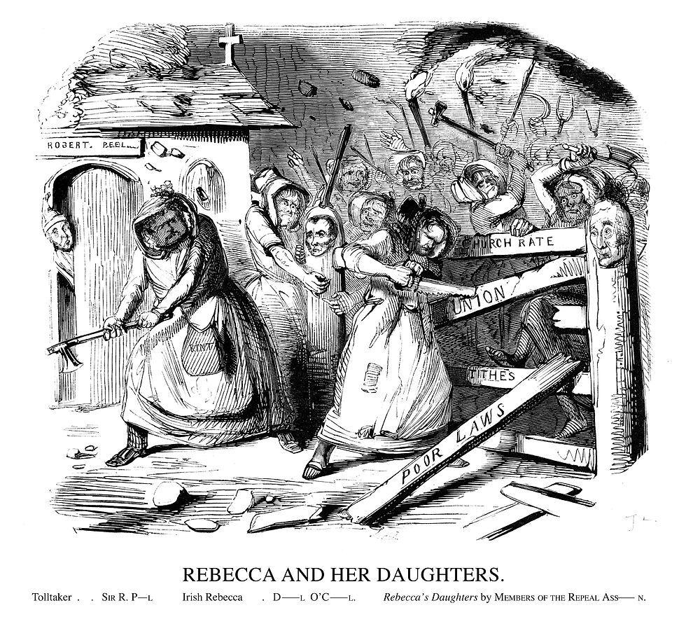
The Rebecca riots took place in the rural parts of Wales in 1839-1843. They were a series of protests made by tenant farmers against the payment of tolls (fees) charged to use the roads. Turnpike Trusts, or groups of businessmen, owned most of the main roads. These men fixed the charges and decided how many tollgates (turnpikes) could be built.
During the riots, men disguised as women attacked the tollgates. They called themselves ‘Rebecca and her daughters’. This is most likely to be after a passage in the Bible where Rebecca talks of the need to ‘possess the gates of those who hate them’ (Genesis XXIV, verse 60). People at that time knew the Bible well.
Tolls were a big expense for small farmers, who used the roads to take their crops and animals to market, and also to collect lime (a chalky mineral). Lime was used to improve the quality of the soil so farmers could grow better crops. It could cost as much as five shillings (25p) in tolls to move a cart of lime eight miles inland. The people of west Wales did not want to pay to use their roads.


Comments